The Impact of Hotmap
Danyel Fisher
Microsoft Research
Published here: May, 2009
 |  | Full article |
Summary of the Tool
Hotmap was released internally at Microsoft in 2006 as a research prototype; its use was monitored as it was developed further. A public edition of Hotmap was released in 2007; the authors have collected feedback on that tool since.
Summary of its Impact
Document Usage to Improve Usability
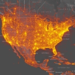
Hotmap was used to allow the Virtual Earth team to learn what existing imagery VE users liked to look at and ultimately to target the purchase of new imagery, leading to considerable cost savings.
Documenting Errors
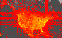
Hotmap acted as a way to catch errors and let the team document the failure mode more clearly to developers.
Documenting Attacks
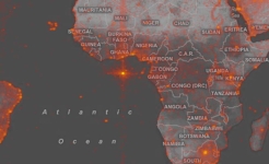
The tool provided awareness of scraping attacks and security measures were designed into later versions.
| 
|
| Figure 1: By showing which tiles were looked at. The team could decide where to purchase further imagery. | Figure 2: Hotmap allowed finding bugs in early versions like this frequent reference to coordinate (0, 0). |
| |
| Figure 3: Hotmap allowed finding areas where data was scraped calling for security measures to be put in place. |
Range of Impact
There were many different parts of the Virtual Earth team that were informed by Hotmap. The developer API, imagery planning, marketing, and usability groups all used Hotmap to understand better how VE was being used and developed. Also outside vendors benefited after the tool's public release.
Links
- A public edition of Hotmap
- Research paper first presenting Hotmap at IEEE InfoVis 2007
- Workshop paper presenting Hotmap at the CHI Workshop on Imaging the City.
Copyright of article and images belongs to the author or his employer